DATA DETAILS > LAND USE
The feature classes below are stored in the project database within the "landuse" feature dataset. Recommended Uses: reference layers on maps; use as geoprocessing inputs for additional spatial analysis.
Land use was classified into 11 described below. In addition, several other observations (e.g. irrigation) were recorded.
Land Use Categories
|
Browse Visual Examples
|
Additional Land Use Characteristics
|
|
Coded Values
Most attributes in the land use data are set up as coded-domains, which ensure data quality and consistency. Coded-domains appear as drop-down lists when the feature class attribute tables are viewed using Esri's ArcGIS Desktop software. When exported into another format (e.g. a shapefile or csv file), the drop-down functionality is lost; all attributes with coded-domains will display a code instead of the corresponding text description.
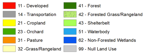
Land Use Coded ValuesThe numeric values for land use are very similar to those used in the Anderson Land Use and Landcover Classification System.
|
Other Coded ValuesY = Yes; N = No.
Related attributes: Uncertain, Field_outside_grid, Irrigated, Hatching, Successional PI = Poor Imagery; DD = Difficult to Distinguish;
O = Other. Related attributes: Why_uncertain |
Land Use Feature Classes
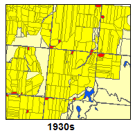
lu_1930s
|
Spatial Information: 88,927 records; each polygon and row = one "field" (an area of contiguous land use like a crop field or water body).
Format: file geodatabase polygon feature class Feature Dataset: landuse Primary Key: OBJECTID Attributes:
Scale: Polygons were digitized at 1:4,800; minimum mapping unit = 30 meters. Source: Custom dataset created by manually interpreting aerial photos. |
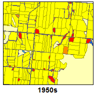
lu_1950s
|
Spatial Information: 94,194 records; each polygon and row = one "field" (an area of contiguous land use like a crop field or water body).
Format: file geodatabase polygon feature class Feature Dataset: landuse Primary Key: OBJECTID Attributes:
Scale: Polygons were digitized at 1:4,800; minimum mapping unit = 30 meters. Source: Custom dataset created by manually interpreting aerial photos. |
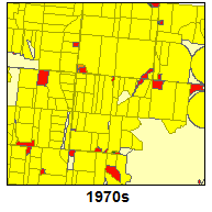
lu_1970s
|
Spatial Information: 74,382 records; each polygon and row = one "field" (an area of contiguous land use like a crop field or water body).
Format: file geodatabase polygon feature class Feature Dataset: landuse Primary Key: OBJECTID Attributes:
Scale: Polygons were digitized at 1:4,800; minimum mapping unit = 30 meters. Source: Custom dataset created by manually interpreting aerial photos. |
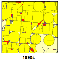
lu_1990s
|
Spatial Information: 75,032 records; each polygon and row = one "field" (an area of contiguous land use like a crop field or water body).
Format: file geodatabase polygon feature class Feature Dataset: landuse Primary Key: OBJECTID Attributes:
Scale: Polygons were digitized at 1:4,800; minimum mapping unit = 30 meters. Source: Custom dataset created by manually interpreting aerial photos. |
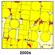
lu_2000s
|
Spatial Information: 69,628 records; each polygon and row = one "field" (an area of contiguous land use like a crop field or water body).
Format: file geodatabase polygon feature class Feature Dataset: landuse Primary Key: OBJECTID Attributes:
Scale: Polygons were digitized at 1:4,800; minimum mapping unit = 30 meters. Source: Custom dataset created by manually interpreting aerial photos. |