DATA DETAILS > NATURAL FEATURES
The feature classes below are stored in the project database within the "natural_features" feature dataset. The tables are stored in the project database outside of a feature dataset. Recommended Uses: reference layers on maps; create additional soil attributes for further analysis.
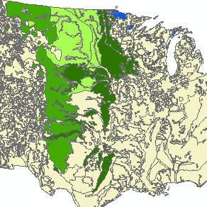
kucher_vegetation
|
Spatial Information: 2,497 records; each polygon and row = one conterminous vegetation zone.
Format: file geodatabase polygon feature class Feature Dataset: natural_features Primary Key: OBJECTID Attributes:
Scale: unknown. Source: unknown. |
Custom Soil Datasets
The four datasets listed below are customized versions of the SSURGO Soils Database with attributes used in our final analysis. Three datasets are dissolved versions of the first; they are helpful for creating maps of the soil results.
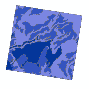
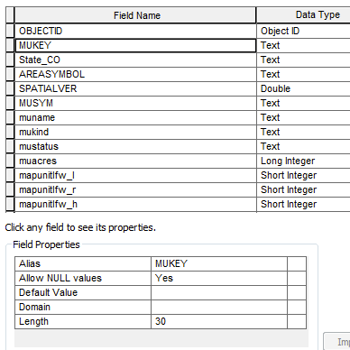
soil_summary
|
Spatial Information: 3,211 records; one row for each soil map unit within the study area; each polygon and row = one soil map unit.
Format: file geodatabase polygon feature class Feature Dataset: natural_features Primary Key: MUKEY Attributes:
Scale: 1:24,000 Source: Customized version of SSURGO Soils Database. Soil Map Units were were clipped to the Sample Grid boundaries. Attributes from component tables were summarized for the project. Additional custom variables were added (e.g. NIR_RC). |
soil_NIR_classes
|
Spatial Information: 3 records; multi-part polygons; ~ one row for each non-irrigated soil type within the study area.
Format: file geodatabase polygon feature class Feature Dataset: natural_features Primary Key: OBJECTID Attributes:
Scale: 1:24,000 Source: soil_summary feature class dissolved by NIR_RC codes. |
soil_IR_classes
|
Spatial Information: 3 records; multi-part polygons; ~ one row for each irrigated soil type within the study area.
Format: file geodatabase polygon feature class Feature Dataset: natural_features Primary Key: OBJECTID Attributes:
Scale: 1:24,000 Source: soil_summary feature class dissolved by IR_RC codes. |
soil_prime_farmland
|
Spatial Information: 13 records; multi-part polygons; one row for each prime farmland designation.
Format: file geodatabase polygon feature class Feature Dataset: natural_features Primary Key: OBJECTID Attributes:
Scale: 1:24,000 Source: soil_summary feature class dissolved by farmlndcl codes. |
Compiled Raw Data for Soils within the Study Area
The datasets below can be used to create new soil attributes for further analysis.
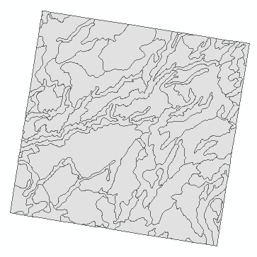
soil_map_units
|
Spatial Information: 3,211 records; one row for each soil map unit within the study area; each polygon and row = one soil map unit.
Format: file geodatabase polygon feature class Feature Dataset: natural_features Primary Key: MUKEY Attributes: All attributes were removed except the MUKEY. Coded Domains: none Scale: 1:24,000 Source: Customized version of SSURGO Soils Database. Soil Map Units were were clipped to the Sample Grid boundaries. |
1_ soil_map_units
|
Spatial Information: 3211 records; one row for each soil map unit within the study area.
Format: file geodatabase table Feature Dataset: none Primary Key: MUKEY Attributes:
Scale: NA Source: SSURGO soils databases for all 50 study counties. All records that don't link to a soil map unit inside the study area have been removed. |
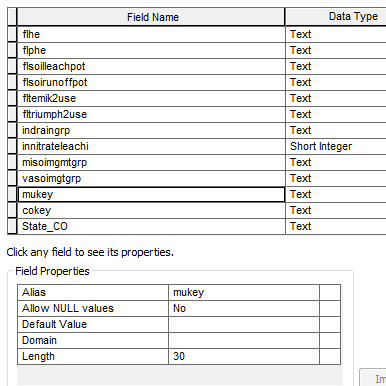
soil_2_component
|
Spatial Information: 20,317 records; one row for each soil component that links to a soil map unit within the study area.
Format: file geodatabase table Feature Dataset: none Primary Key: cokey Attributes:
Scale: NA Source: SSURGO soils databases for all 50 study counties. All records that don't link to a soil map unit inside the study area have been removed. |
soil_3a_chorizon
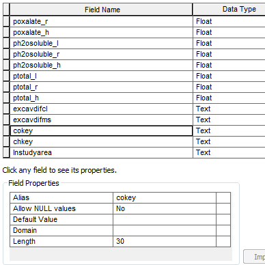
|
Spatial Information: 66,828 records; one row for each soil horizon that links to a soil component and soil map unit within the study area.
Format: file geodatabase table Feature Dataset: none Primary Key: chkey Attributes:
Scale: NA Source: SSURGO soils databases for all 50 study counties. All records that don't link to a soil map unit inside the study area have been removed. |
soil_3b_ccropyld
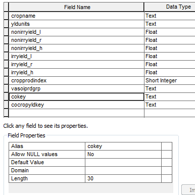
|
Spatial Information: 22,049 records; one row for each record that links to a soil component and soil map unit within the study area.
Format: file geodatabase table Feature Dataset: none Primary Key: cocropyldkey Attributes:
Scale: NA Source: SSURGO soils databases for all 50 study counties. All records that don't link to a soil map unit inside the study area have been removed. |