QUALITY ASSURANCE
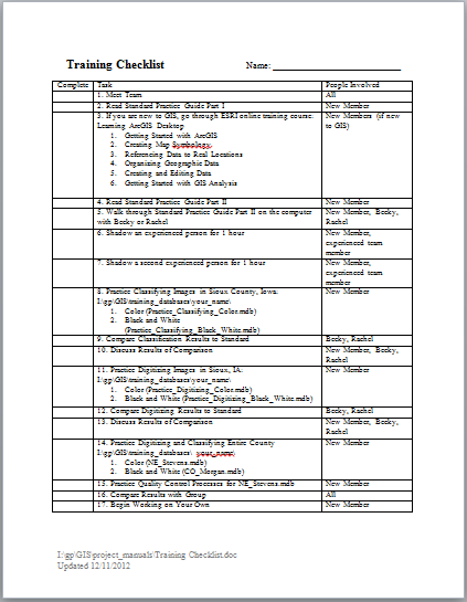
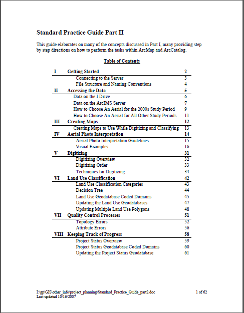
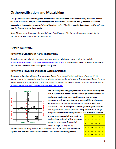
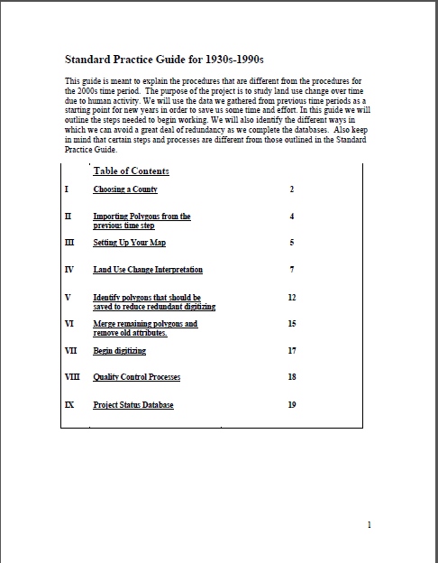
Standardized WorkflowsAll project workflows were standardized and documented to support data quality. Team members were trained and evaluated by the GIS Manager before beginning each main step. Examples of the the documentation are shown below.
|
Quality Control TasksEnsure final land use change analysis results were calculated correctly. GIS Manager (RK):
Ensure land use interpretations are plausible. Project Investigator (KM): Find the total area of land within each category for each county. Compare to agricultural census. Note: Difficult to directly compare the two datasets since they use different land use categories and definitions in some cases.
Ensure land use changes over time are plausible. GIS Manager (RK): Intersect land use datasets (30s & 50s; 50s & 70s; 70s & 90s; 90s & 00s; 30s & 00s). Create change matrices comparing total area of land in each category by year. Flag mysterious changes like forests changing into water. Note: Results led us to conclude that we should combine some of the land use categories due to difficulty distinguishing between them consistently.
Ensure land use interpretations by student team are reasonably accurate. An "expert" (AD) familiar with land use change duplicated the classification process for 10% of the sample area for one year (2000)s. Note: The results are not directly applicable to the final dataset. The comparison used an earlier draft of the land use data created by the student team, which has been significantly altered in the final version.
Ensure consistency in land use classification between team members over time. Student Leader (CH): Using compiled databases by UTM Zone, visually check each sample grid for false changes in land use due to interpretation differences between team members. Compare land use for each year against corresponding aerial photo. Manually adjust land use inconsistencies. Do not update field boundaries.
Eliminate duplication errors during database compilation process. Student Leader (CH): After compiling county database by UTM Zone, run topology rules & correct errors (overlaps and gaps) in landuse data vs. sample grids. Eliminates import duplication errors during compilation process.
Eliminate digitizing & classifying errors during data creation process. All Students: After digitizing and classifying each sample grid, run topology rules & correct errors (overlaps and gaps) in landuse data vs. sample grids. Run attribute queries to check for missing data.
|